 Conn Home
%) Topographical Survey's
Topographical Survey's%) Loan Survey's
Loan Survey's%) Subdivisions
Subdivisions%) Construction Staking
Construction Staking%) Boundary Survey's
Boundary Survey's%) ALTA Surveys
ALTA Surveys Examples
 Contact Us
 Links
Links Staff
Staff Work Order
 KR
KR File Sharing
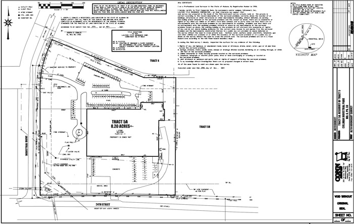
ALTA Survey: What it Shows and Why It Is Important
An ALTA survey is
performed to standards jointly adopted by the American Land Title
Association and the American Congress on Surveying and Mapping. The
detailed standards guide the surveyor in preparing a survey that
meets the needs of the buyer and the requirements of the title
insurer.
An ALTA survey is one means of reducing risk in a real estate
transaction. The process of preparing an ALTA survey may show that
possession or use of the property does not conform to record
information, with the result that the extent of title and rights do
not always conform to the boundaries set forth in a deed. An ALTA
survey provides detail, such as fences, trails, roads, utility
lines and other features of the property, and may highlight the
need for further investigation into the possibility of adverse
rights. Also, an ALTA survey can establish that the legal
description being relied upon in the purchase contract and deed can
be used to actually locate the property on the ground.
If a buyer requires an extended coverage owner’s title policy, it
must provide the title insurer with an ALTA survey so that the
insurer can delete the standard exceptions for (i) easements, or
claims of easements, not shown by the public record; and (ii)
encroachments, overlaps, boundary line disputes, or other matters
that would be disclosed by an accurate survey and inspection.
(A boundary survey shows the boundary lines between parcels of
land, but not necessarily any improvements on the land. It does not
conform to uniform requirements and does not typically show the
level of detail that a buyer of commercial real estate needs to
evaluate.)